I still remember the first version of this project from my bachelor’s degree in Computer Science. The title itself sounded ambitious at the time: Satellite Image Processing using Cloud Computing. The idea was to store and process large satellite images in a virtual cloud environment instead of trying to handle everything locally on a regular machine. That part felt exciting to me because satellite images are big, heavy, and not always easy to work with, so the cloud seemed like a practical way to deal with them.
Where It All Started
In the first draft, the project was mostly about understanding the basics. I was not trying to build something highly advanced yet. I was more focused on learning how satellite images could be loaded, prepared, and processed in a cloud-based setup. It was a simple beginning, but it gave me a first real look at how remote sensing data can be handled when storage and computation are separated from the local computer.
What I liked about that early idea was how clearly it connected two things: image processing and cloud computing. On one side, there was the image itself, full of pixel data and visual patterns. On the other side, there was the cloud environment, which made it possible to think about larger datasets and more scalable workflows. Even then, I could see that this was not just about one image — it was about learning how to deal with satellite data in a smarter way.
Curious about the code (make sure you open and run on desktop with Google Colab 😉)
Coming Back With New Learnings
As my skills improved, I came back to the same idea but with a more focused, image-centric approach. Instead of only thinking about storage and basic processing in a cloud environment, I started exploring what the satellite images themselves could tell me. This shift changed everything for me: the image stopped being just a file to upload and became something I could actively analyze.
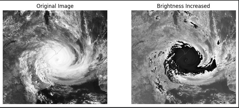
I began working with cyclone satellite images and classical image processing methods that are simple, interpretable, and good at revealing visual patterns. Grayscale conversion and small brightness adjustments were my first steps, cleaning the data and making details easier to see. From there, I used texture and edge-based methods to study cloud structure and storm boundaries, realizing that the image itself carries a lot of information if you know how to read it.
The Methods I Use Now
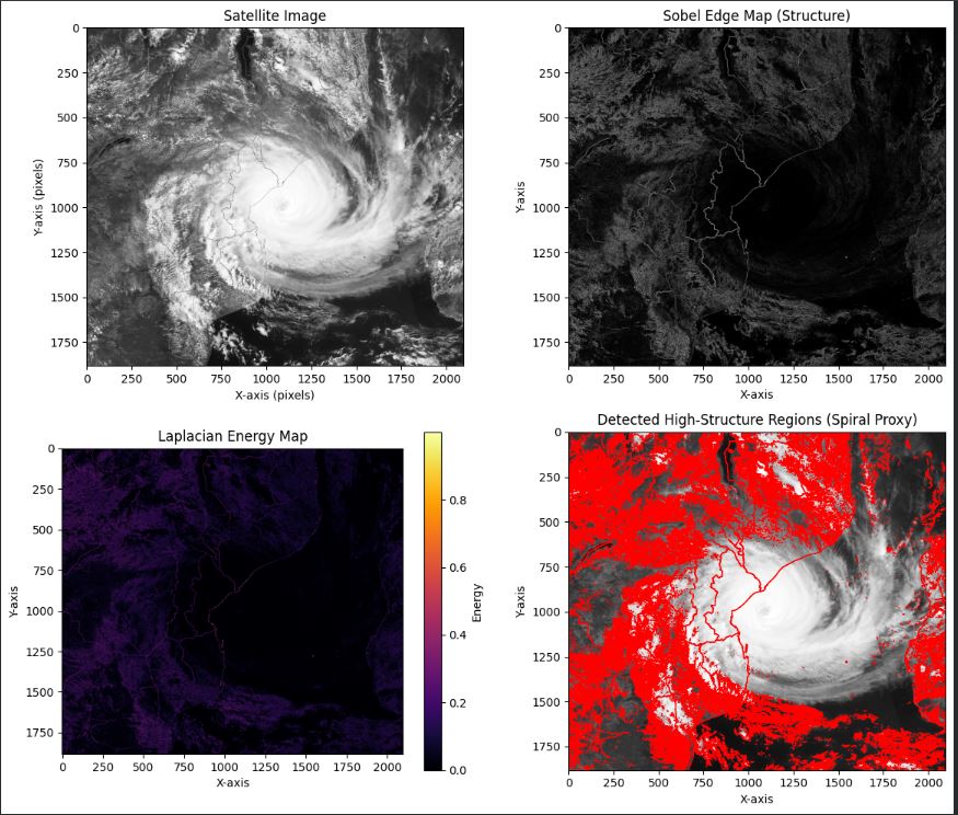
GLCM for Texture
GLCM is used to measure texture properties such as contrast, energy, and homogeneity. These values help describe how complex or organized the cloud pattern looks. In cyclone imagery, texture is important because storm systems often have layered and swirling structures.
Sobel Filtering for Edges
I also use Sobel filtering to detect edges. This helps highlight the storm boundaries and other strong visual transitions in the image. In satellite analysis, edges are useful because they often correspond to changes in cloud density or structural organization.
Laplacian for Intensity Changes
Then I use the Laplacian operator to pick up rapid intensity changes. This is useful for identifying more energetic or sharply defined regions in the cyclone image. It adds another layer of information that helps the image feel less like a flat picture and more like a structure with different levels of activity.
Curious about the code (make sure you open and run on desktop with Google Colab 😉)
Estimating the Cyclone Center
Another important part of the current project is estimating the cyclone center. I use a mass-weighted centroid idea, where pixel intensity helps determine the approximate center of the storm. It is a simple method, but it makes intuitive sense, because brighter or denser regions in the image can influence where the center seems to be.
Turning Features Into a Severity Score
After that, all of these extracted features are combined into a severity score. That score is not meant to replace expert analysis, but it gives a structured way to interpret the image. Instead of just saying “this looks strong” or “this looks weak,” the system turns the visual information into a readable result. That makes the project feel more complete and more practical.
Why This Project Matters to Me
What I like about this project is that it grew naturally from a very small college idea. It started with the simple thought that satellite images could be processed in the cloud. Over time, that became a deeper interest in understanding what those images actually show.
When I look back at the old project now, I see it differently. At the time, I was just trying to make something work. I was exploring a topic that felt new and challenging, and I did not fully know where it would lead. Now I can see that the project was more important than it first appeared.
A Record of Growth
It gave me a starting point. It introduced me to satellite imagery, cloud-based processing, and the idea that image data can be analyzed in many different ways. More importantly, it gave me a reason to keep learning. The new version of the project feels like a continuation of that same curiosity, but with better tools and a deeper understanding.
That is what makes it special to me. It is not just a technical project. It is a record of growth.
Repository Link: Cyclone Satellite Image Analysis System